Integrated Water Resources Management, migration and water transfer |
 |
|||
Steffen Niemann |
||||
 |
||||
|
The geographical sub-project in • interbasin (= watershed crossing) water transfer on the one hand and • the increasing emphasis on hydrological catchment areas as the spatial planning unit on the other hand. |
||||
|
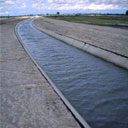
One of the most important demographic trends of the present time – apart from global population growth, regional stagnation or reduction, ageing and its associated problems – is continuous migration. A population concentration is taking place beyond availability of natural resource: In the pre-industrial era, natural resources’ availability was the main criterion for the selection of places to settle. Later, accelerated especially during the time of industrialisation and supported by the increasing population pressure, other aspects became more important. Changed circumstances led to the emergence of new settlements, continuous immigration intensified this development. Today, the distribution of the global population is less related to the availability of natural resources e.g. fresh water. It therefore follows that many densely populated areas are in places which lack appropriate fresh water resources to satisfy the inhabitants’ demands. Assuming that this development will continue, large water transfers will in future be one of the most important measure to secure water supply. A man-made net of water rearrangement will be introduced into the natural water cycle. The demographic development described above, necessitating water transfer as simple means of water supply, have in recent years been flanked by another innovation. Therefore water transfer acquires a formerly unforeseen difficulty: Sustainable water resources management, as becomes increasingly clear, can only be organised on the basis of the hydrological basin area as planning unit (instead of on the basis of national states). This applies to national level as well as to international level. The hydrological integration of virtually any water-related measure, where- or whenever, has (in almost all cases) direct subsequent effects within the affected catchment area. This circumstance is reflected in the new “magic word” Integrated Water Resources Management (IWRM), that has become very popular as a concept of water management. The European Water Framework Directive (EWFD), adopted in 2000, could globally be seen as a milestone in the respective transformation of water resources management. In this document IWRM has for the first time been used for a whole confederation of states – instead of for an individual catchment area. From a hydrological and ecological point of view, the detachment of a nation-based thinking in the field of water resources management is certainly a very meaningful step. However, in the technical-scientific arena, it has hitherto hardly ever been discussed that, in the end, this new focus merely replaces politically-defined boundaries by other (hydrologically determined) ones. The problem becomes obvious in the case of water transfer: It is, as soon as it exceeds watersheds (borders between different surface water’ catchment areas), an expansion of the supply area beyond the catchment area. It therefore requires some kind of continuous re-arrangement of the participants spectrum and – some users will be from outside the area – for IWRM not to become a source of friction and in the long term impede all planning efforts. This geographical and application-oriented sub-project’s core is the analysis of potentials and restrictions of water transfer projects taking IWRM into account. It is looking for ways to integrate water transfer projects (where they appear necessary) in future-oriented planning and water resource management. This is being done by, simultaneously, keeping in mind the over-all research scope of November 2003 |
||||